About Delbarton West Virginia
Incorporated on September 6, 1946 by the Mingo County Circuit Court. Delbarton was named after the country estate of Luther Kountze, located in Morristown New Jersey, who was the largest shareholder in the United Thacker Coal Company, which had extensive timber and mine holdings in Mingo County. For the history of Delbarton, please see “Our History”.
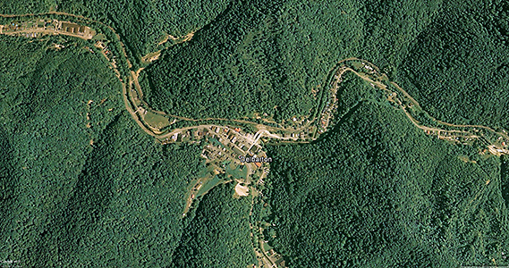
Delbarton is located in the heart of the Appalachian Mountains and the “Billion Dollar Coal Fields” in Mingo County, at the intersection of the three major highways serving the area, U.S. Route 52, State Route 65 and County Route 65/18. The town contains aproximately 2 square miles of land mass, with less than 1% being covered by water, the main streams being Pigeon Creek and Rockhouse Fork. In 2008, there were 432 residents.
How We Operate
Government
The Town is governed by an elected Mayor and five-person Town Council. The Delbarton Town Hall is located at 1891 Rt.65 which also houses the Police and Utilities Departments. The Town Council meets at the Council Chambers of the Delbarton Town Hall on the 2nd and 4th Monday of each month at 6 pm.
Elections
Town elections are held every four years on the second Tuesday in June. Newly elected officials take office on July first. The next election will be held June 6, 2023.
Services and Utilities
Water is purchased from the Public Service District and provided by the DWWT (Delbarton Waste/Water Treatment) to residents and businesses within the city limits and surrounding areas along portions of Route 65 and 52, our Waste Treatment plant is one of the few in the state using UV Irradiation Disinfection system. Some residents use private wells and septic systems.
Electricity is provided to Delbarton residents by Appalachian Power Company.
Law Enforcement and Emergency Services
Law enforcement is provided by our Chief of Police Earl Spence and 3 police officers, John Hall, Jr., Joshua Tincher and Trevor Layne.
Supporting DCPD is the Mingo County Sheriff and Deputies, and by West Virginia State Police officers assigned to Mingo County.
Medical emergencies are handled by Stat EMS Ambulance Station 6.
All fire emergencies are handled by the Delbarton Volunteer Fire Department.
(NOTE: All emergency calls for police, fire, or rescue assistance go through the Mingo County 911 system. You can reach the Delbarton Police Department for non-emergencies at 304-475-3359.)
Educational Facilities
Public Schools
The Mingo County Board of Education is governed by a five-member School Board elected at large. The Board meets on the first Thursday of the month at 6 pm. Day-to-day administration of the public school system rests with the Superintendent of Schools, who with the employees of the school board and school principals, to provide leadership in carrying out Board policies for the day-to-day operations.
There are three public schools in the Delbarton zip code that are governed by the Mingo County Board of Education.
Burch Pre K-8th School
Mingo Central High School
Mingo County Extended Learning Center
Mingo Central High School (9-12)
1000 King Coal Highway
Delbarton, WV 25670
Phone: 304-426-6603
Fax: 304-426-6605
Website: Mingo Central High School
Burch PK-8 School
275 Bulldog Blvd.
Delbarton, WV 25670
Phone: 304-475-2700
Fax: 304-475-5106
Website: Burch PK8
Mingo Career & Technical Center
165 Bulldog Blvd.
Delbarton, WV 25670
Phone: 304-475-3347
Fax: 304-475-3797
Website: Mingo Extended Learning School
Private Schools
There is one private school in Delbarton, Regional Christian School, operated by the Regional Church of God.
New Beginnings Christian School
US RT 65
Delbarton WV 25670
Phone: 304-475-3894
On Facebook
Public Airports

Appalachian Regional Airport
Appalachian Regional Airport (ICAO; KEBD,FAA LID; EBD)
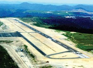
Publicly owned by the Mingo County Airport Authority, the Mingo County Air Transportation Park is located 3.64 miles southeast of Delbarton Town Square, on a reclaimed surface mine within the Delbarton zip code at an elevation of 1,883.2 feet (574.0 m). It opened in December of 2012 and was created in a joint effort between Alpha Natural Resources, who donated 975 acres for the project, the Mingo County Airport Authority, Mingo County Redevelopment Authority, FAA and the West Virginia Aeronautics Commission. Its FAA Identifier is EBD, and its runway is 5,001 feet long (1,524 m) and 75 feet wide (23 m), lighted, and is oriented in a general southwest by northeast direction. Its GPS location is at 37.6817640 / -82.1220666. There are 9 aircraft based on the field. Aircraft operations average 200 flights per year, with 100% being local general aviation. The airport is open to the public, but is currently unattended. It can be accessed via Old Field Branch Road (Mingo County Highway 52/15) from Varney, WV or Ragland, WV.


